In this short video, we will:
1.) Highlight the benefits of creating a context model and give a high-level process of how the model was created.
2.) We will talk about a more efficient way to capture existing conditions and why it is important to have up to date GIS information.
3.) Show how to real-time update GIS data from the field with the Collector for ArcGIS app.
Author Name: John Sayre
Products used: InfraWorks, ReCap Photo/Pro
Follow us on Twitter: @AutodeskCivil3D
Follow us on Facebook: https://autode.sk/2V66NZH
Subscribe to the Blog to stay up to date: https://autode.sk/2BZSjUt
—————————————————————————————————————
Script
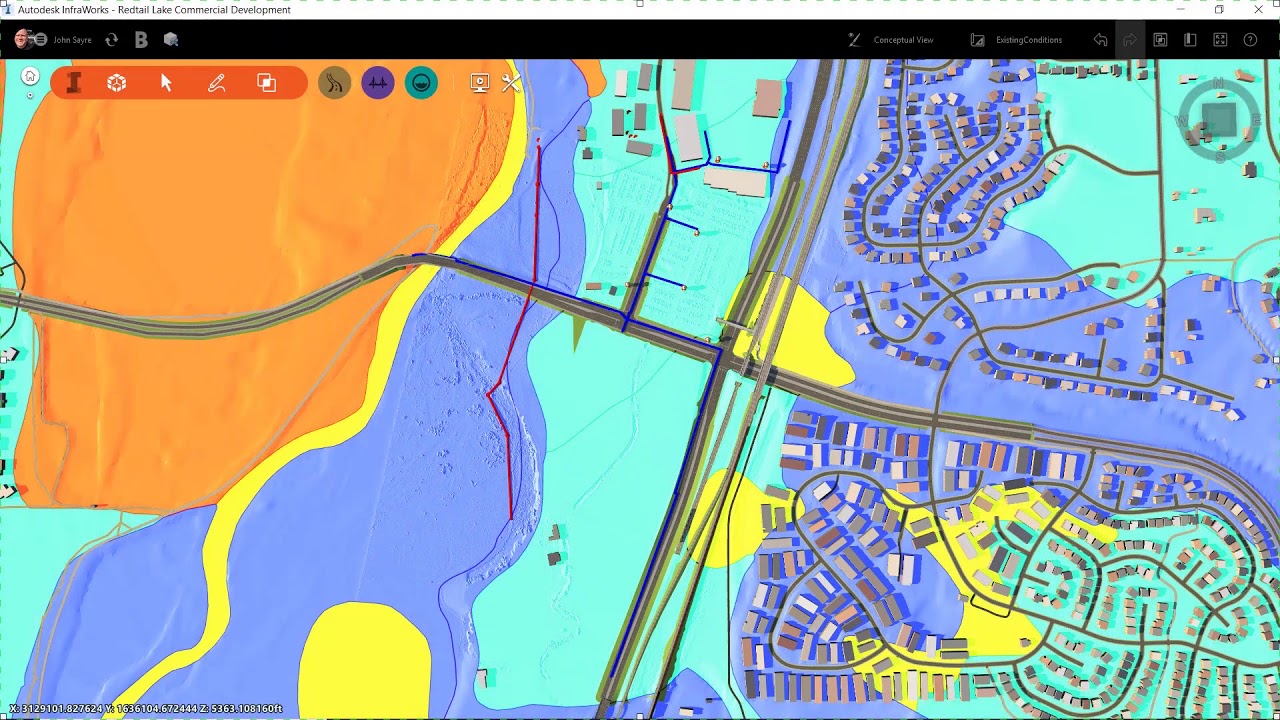
Every project starts with a concept. Being able to visualize the project concept in a 3d contextual environment, allows all stakeholders to understand the project from the very beginning. It all starts in InfraWorks by using Model builder to define the site and begin the data aggregation process. Understanding the existing conditions of the site is key. Traditional methods of capturing existing conditions can be time-consuming. But by using the drone to design workflow which includes Autodesk Recap, you can collect existing conditions data faster, while maintaining accuracy. This workflow allows you to take advantage of Realtime, up to date imagery and existing ground topography that has been generated from the point cloud. This data is key when making engineering decisions for the project.
To further enrich our context model, you can take advantage of the Autodesk Connector for ArcGIS. This allows us to further populate our model with GIS Data. This data could represent Existing Utility locations, Fema Floodplain data and soils data as examples of information that will help us to make design decisions in the preliminary stages of the project.
Focusing on Preliminary Design and with our context model populated with rich GIS data, we are ready to run specific types of analysis, such as watershed analysis, which will help to better understand storm water management for our project.
When laying out design alternatives there are times you will need to Verify GIS data. For example, while in the field you can ensure utility locations, and collect additional data for utilities that might have been missed. You can use the Collector for ArcGIS App to Realtime locate missing structures onsite and then populate your model with a simple refresh of the data. This allows you to make faster more accurate design decisions and resolve issues this new data might create.
Creating a context model with accurate existing conditions data coupled with rich GIS data is key for project success. The data in this model will be used from the sketch plan stage of the project, to preliminary design, and will ultimately play a huge roll in the final layout and design of your project.

Comments